


Roads Less Traveled
-
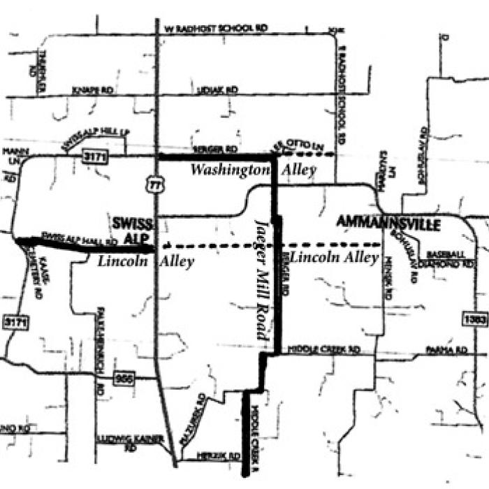 The former locations of Washington and Lincoln Alleys on this map are highlighted with darker horizontal lines. The darker vertical line indicates the location of the old Jaeger Mill Road.
Footprints Of Fayette
Fayette County is one of the most historic counties in Texas. In this weekly feature from the County Historical Commission, a rotating group of writers looks back at local history.
In the late 19th and early 20th century, our county was crisscrossed with small roads leading from one community to another, providing the shortest routes possible for settlers who had to travel by horseback or wagon. Some of these minor roads disappeared when automobiles became popular, and more-traveled roads were better maintained. Farm to Market roads that were already being built in the late 1940s and ‘50s bypassed many smaller roads, resulting in the demise of some. Then the introduction of numbered county roads erased the old names that were eventually forgotten through the years. When doing research on the farms owned by my paternal family in the Ammannsville area, I discovered the names of three roads that seemed to be unknown to anyone still living with memories of that area, specifically, Jaeger Mill Road, Washington Alley and Lincoln Alley. Further research eventually provided the answers regarding their exact locations.
An Ancestry search revealed that an early settler, Karl Traugott Jaeger, sometimes spelled Yeager, emigrated from Saxony, Germany, arriving in Texas in 1854. He first settled in Cat Spring, where he married Louise Luedeke in 1859. He served in the Confederate Army during the Civil War and eventually moved to Fayette County. In October 1879, he purchased 147 acres on Middle Creek between Ammannsville and High Hill. In a special census taken in 1880 enumerating manufacturing businesses, Jaeger was listed as owning a cotton gin, which at that time would have been steam powered. Being close to a water source was advantageous for steam powered mills and gins. A bridge across East Navidad River was known as Jaeger’s Bridge, and the north-south road crossing the bridge was called Jaeger Mill Road.
The County Commissioner minutes at that time stated that the road would officially be classified as a second class road that was connected to a small east/west road called Washington Alley that ran past a rock quarry with a bridge over a gully, extending from the La Grange to Schulenburg Road, present-day Hwy 77 S., to the La Grange Bluff to Weimar Middle Road, now known as E. Radhost School Road. The “alley” was north of and parallel to present-day FM 1283. From its beginning at Washington Alley, Jaeger Mill Road ran south across Navidad Creek to an unstated terminus. It undoubtedly ran near Jaeger’s property on Middle Creek, so was the original name of Middle Creek Road south of the river.
Later, Jaeger Mill Road was designated with a number as part of the county road numbering system. When rural addressing became necessary for more efficient emergency services, the road was renamed Berger Road until it merged with present-day Middle Creek Road. The section of Washington Alley from presentday Hwy 77 S. to its junction with the former Jaeger Mill Road was also renamed Berger Road, resulting in a present-day “L” shaped road. From that intersection going eastward, Washington Alley had already ceased to exist and was absorbed into private property.
Another old road called Lincoln Alley was located south of and parallel to Washington Alley. It is unknown why these roads were called alleys, other than the fact that they were short, straight, connecting roads between two larger roads. Lincoln Alley first ran from the La Grange to Schulenburg Road across Jaeger Mill Road, ending at presentday Mensik Road at a junction south of the Catholic Church in Ammannsville. In 1885, Lincoln Alley was extended westward to the Knippa and Foerster properties and the northwest corner of the old Evangelical Zion Lutheran Church property at the intersection of present-day FM Rd. 3171 and Swiss Alp Hall Road. After the church closed, the building was moved to Schulenburg in 1946. The nearby cemetery, currently known as the Kaase or Kiesling Cemetery, is still evident up on the hill.
FM Rd. 1383 from Hwy 77 to Ammannsville and Dubina was created in circa 1952-1953. A 1936 rural mail route map shows that a road following that exact route to Ammannsville was already in existence. The section of Lincoln Alley west of Hwy 77 S. eventually became Swiss Alp Hall Road, and the eastern section leading to Ammannsville was eventually closed, again at some unknown time, and its name was forgotten.
In late 1881, Jaeger purchased 88 acres closer to High Hill from F.G. Seydler. However, it is unknown if he ever lived on this property. Most of his surviving adult children moved elsewhere, primarily to DeWitt County.At some point, he abandoned his goal of operating a cotton gin, perhaps due to competition with larger, more efficient gins in Ammannsville and High Hill. Jaeger and his wife followed some of their children, settling in the Terryville community west of Yorktown. He died there in 1896. His wife then lived with a daughter in the Nopal community in DeWitt County, where she died in 1909.
In spite of his leaving the county by the 1890s, Jaeger’s name continued to be used for a road and a bridge in Fayette County for years after he left. Eventually, however, the memory of the names of that road, two alleys and a bridge faded into obscurity along with the names of many other small, less-traveled roads in the county.
Sources: Ancestry.com Fayette County Commissioners Court Minutes Fayette County Deed Records – Vol. 11, pp 493-494; Vol. 17, pp 403-404; plat maps Findagrave www.fayettecountyhistory.org – Cemetery Histories