


The Springs of Fayette County
-
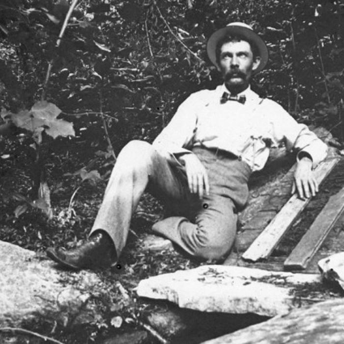 Labeled “Bluff Spring,” Frank Hausmann is shown on the farm belonging to his father, Franz Hausmann. They put the rock ledge over the springs and then the wooden cover and used it like a spring house to keep food cool. Photo courtesy of the Fayette Heritage Museum & Archives
Footprints Of Fayette
Fayette County is one of the most historic counties in Texas. In this weekly feature from the County Historical Commission, a rotating group of writers looks back at local history.
There is an almost magical quality to natural springs. By providing a flow of fresh, clean water from underground aquifers they provide a life-sustaining resource for humans and wildlife. They were often called “fountains” by early settlers, In 1767, Fray Gaspar José de Solís made a tour of the Spanish missions in Texas. In passing through the country from SanAntonio to the Louisiana border he commented on the springs that sustained an abundance of wildlife and a great variety of trees. Gunnar Brune was a geologist with the Texas Water Development Board and made a survey of the springs of Texas between 1975 and 1981. He identified over 2,900 springs in 183 counties, including 12 springs in Fayette County. As settlers moved into the county, springs often determined where a settlement would be established and towns like Blackjack Springs and Willow Springs still tell that relationship. Other towns have names that do not reflect the springs that led to their formation.
The most prominent and historic spring in the county is Monument Spring, known in earlier times as Mount Maria Spring. In 1838 the five commissioners evaluating a new seat of government recommended the site of La Grange in part because of the existence of this spring. Later it became the source of water for the brewery built and run by Heinrich Kreische, the ruins of which can still be seen at Kreische Brewery State Historic Site.
The community of Primm was located near Primm Springs west-northwest of West Point. The springs are along Bartons Creek just southeast of the Primm Cemetery.
Rutersville Springs were located at the site of the historic Rutersville College.
Sylvanus Castleman built his cabin in 1824 near what became known as Castleman Springs. Edward Manton survived the Dawson Massacre and was taken prisoner by the Mexican army. After returning from Mexican prison he purchased the land from Castleman and renamed the water source to Manton Spring.
Big Spring is located between Big Spring Hill Church and Roznov. It was also known as Spencer Pool and is now located underneath the flood-control reservoir on Spencer Pool Creek.
Willow Springs are located on the northeast side of the community to which they gave their name in 1833.
The settlement of High Hill was established in the 1830s just west of High Hill Springs. These springs once had enough flow to supply a brewery and a large swimming hole.
Lyons Springs were located just south of Lyons cemetery and the settlement of that name. Local resident Emil Sommer said that they stopped flowing around 1923.
The settlement at Blackjack Springs grew up around those springs flowing along Rocky Creek. These springs entered history in 1842 when Captain Nicholas Dawson and his men camped there for the night on their march to fight the Mexican army at the battle of Salado Creek near San Antonio. Before they could join up with the other Texian forces they were outnumbered and surrounded by Mexican troops in what is known as the Dawson Massacre.
Pine Springs were located about 2 ½ miles northeast of Flatonia. Now only the Pine Springs cemetery marks the place of the settlement and the springs that gave it its name.
About 2½ miles southwest of Flatonia, Cedar Creek arises from the Cedar Springs.
Just west of Cistern are Cistern Springs which appeared on an 1882 railroad map.
These springs are by no means the end of the story. Other unnamed springs were equally important to the families that lived near them. In Cozy Corner a continuously flowing spring near the Bethlehem African Methodist Episcopal Church provided drinking water for the congregation. It fed an unnamed stream that is a tributary to Lane Pool Creek. This stream was used for baptisms and even clothes washing. As a bonus wild mint grew on the banks and was used medicinally.
Settlers would often improve their springs by building a “spring house” over them, as Frank Hausman shows in the photo of Bluff Spring. The spring house might be made of wood or stone. It would have walls and even a roof to protect the water from trash or animals. By holding back the flow of water it would create a deeper pool for dipping out the water.
Starting in the mid-to-late 1800s settlers began to dig and later drill wells to supply water. These wells tapped the same underground aquifers that fed the springs. Inevitably the level of water in the aquifers began to drop and the springs ceased to flow. Still their names and locations are embedded in the landscape and history of Fayette County.
Sources: “Bethlehem African Methodist Episcopal Church—An Historic Landmark,” by Bobbie Houston, Fayette County Record, August 1, 2017.
Fayette Heritage Museum and Archives photograph collection.
“Diary of a Visit of Inspection of the Texas Missions Made by Fray Gaspar José de Solís in the Year 1767-68,” by Margaret Kenney Kress, with introduction by Mattie Austin Hatcher, Southwestern Historical Quarterly, July, 1931.
Handbook of Texas Online, article about Edward Manton. Springs of Texas, by Gunnar Brune, Second Edition, 2002.